
Summary of Geiger Backpack with Intel Edison
This project by Verona FabLab is a portable "Geiger Backpack" powered by an Intel Edison, designed to measure ambient radioactivity and GPS location while cycling. It logs data to a cloud database via smartphone WiFi, allowing users to visualize radiation heatmaps upon return. The initiative aims to raise public awareness about environmental monitoring without replacing official government activities.
Parts used in the Geiger Backpack:
- Intel Edison dev board
- GROVE Base shield
- Cooking Hacks Arduino shield (Geiger shield)
- J305ß Geiger tube
- GROVE GPS module
- GROVE cable
- Node.js application
- Ubuntu server with Apache webserver
- Node-RED flow
- MySQL database
- HTML page with Leaflet map and heatmap plugin
- PHP script for data extraction
We are a group of makers who like to spend nights and weekends tinkering with tecnology here at Verona FabLab (Verona is a town in the North of Italy) and with this instructable we want to describe the project we’ve realized for Intel Maker contest.
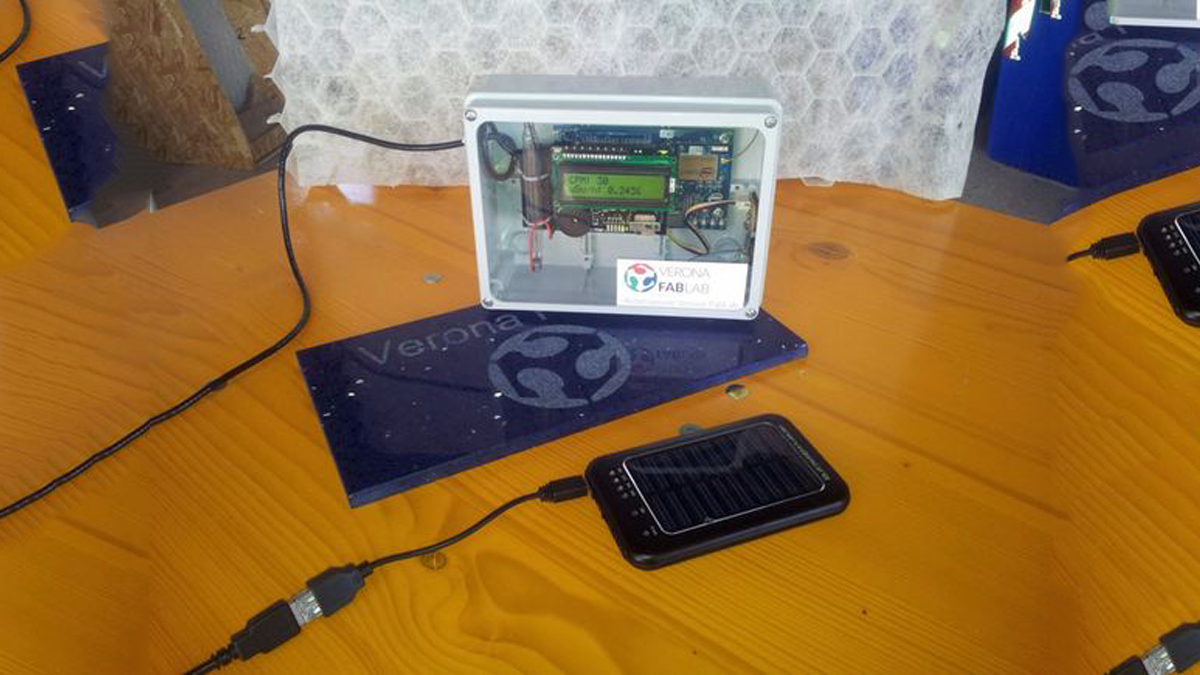
Our project is a portable device powered by an Intel Edison and equipped with a GPS receiver and a Geiger Tube, a sensor able to detect radioactivity.
Our device continuosly measures ambient radioactivity and GPS position and saves them on a cloud database using your smartphone as a WiFi hotspot.
You can turn on your device, put it inside you backpack (here’s the origin of the name), pick up you bike and ride all around you town. When you’re back at home you can view a heatmap of radioactivity level you encountered during your ride.
Our project doesn’t want to mimic governmental environment protection activities, we just want to involve citizenship and make people aware that taking care of our planet is everyone’s duty.
Step 1: How it works
The Geiger tube is a glass tube fullfilled with a special gas and kept at high voltage (500V).
When a radioactive isotope decays, it generates a radiation which can be of 3 types: alpha, beta, gamma.
When the Geiger tube is hit by a radiation, it generates an electrical signal which is detected by the electronics circuits of the hosting Cooking Hacks Arduino shield.
We have the J305ß as the tube for the radiation sensor board as it is fairly sensible to Beta and Gamma radiation.
This shield, is stacked over a GROVE base shield which is stacked over an Intel Edison dev board.
A GROVE GPS is connected to the GROVE base shield.
The Intel Edison detects the interrupts generated by the Geiger shield and computes an average value called CPM (Counts Per Minute) and every 10 seconds it queries the GPS and sends a payload to the cloud server with the current CPM and GPS coords.
Step 2: The Hardware
No soldering is required for this project!
Just stack all the shields, from bottom to top: Intel Edison dev board, GROVE Base shield, Geiger shield.
The GPS must be connected to UART of the GROVE Base shield using the GROVE cable.
Step 3: The software
The software running on the Intel Edison is composed by:
- an application in nodejs installed into Intel Edison, It manages the measurement, capture position by GPS, save the data in the local database, set response on the LCD display and send them to the cloud.
On the cloud part we have:
- an Ubuntu server running Apache webserver and nodejs
- a node-red flow that receives the payloads from the Geiger Backpack and saves them on a database
- a MySQL database
- an HTML page with a Leaflet map with heatmap plugin for data visualization
- a php for database data extraction
Download the source code from github: https://github.com/VeronaFabLabRepo/intel_maker_geiger
Read more: Geiger Backpack with Intel Edison
- What components are stacked to build the hardware?
The hardware consists of the Intel Edison dev board at the bottom, followed by the GROVE Base shield, and finally the Geiger shield on top. - How does the device transmit data to the cloud?
The device uses the user's smartphone as a WiFi hotspot to send payloads containing CPM values and GPS coordinates to a cloud server. - What type of radiation does the J305ß tube detect?
The J305ß tube is sensitive to Beta and Gamma radiation. - How frequently does the device query the GPS and send data?
The system queries the GPS every 10 seconds and sends a payload to the cloud server with the current data. - Can users view the collected data visually?
Yes, users can view a heatmap of radioactivity levels encountered during their ride using an HTML page with a Leaflet map. - Is soldering required for this project?
No, soldering is not required as all shields are stacked together and connected using cables. - What software runs on the cloud server?
The cloud runs an Ubuntu server with Apache, a Node-RED flow, a MySQL database, PHP, and an HTML visualization page. - What is the purpose of the Node.js application on the Edison?
The Node.js application manages measurements, captures GPS positions, saves data locally, updates the LCD display, and sends data to the cloud. - Does this project replace governmental environmental protection activities?
No, the project explicitly states it does not want to mimic governmental activities but rather involves citizenship in monitoring.
