
Summary of GPS vs. Beacons vs. Wi-Fi: Three Location Identifier Technologies
Summary: Location-based services use GPS, WiFi, and Bluetooth Beacons to determine user location for applications like geofencing marketing. GPS excels outdoors using satellite receivers and NMEA messages; WiFi-based positioning and modules like ESP32/ESP8266 are useful indoors near hotspots; Beacons (BLE) serve custom proximity detection, especially inside buildings or retail spaces.
Parts used in the Location-based (Geofencing) Marketing Project:
- GPS module/receiver (e.g., Neoway or u-blox)
- GPS antenna (ready-made antenna attached to module)
- Microcontroller unit (MCU) with UART
- WiFi transceiver module (e.g., ESP32 or ESP8266)
- Bluetooth Low Energy Beacons (custom BLE profile)
In IoT and digital age, location-based services applications are widespread: starting from Google maps to anti-loss devices and not ending with location-based marketing. The most common technologies used for user location identification are: GPS, WiFi and Beacons (a custom BLE profile).
Location-based (geofencing) marketing is a new way to enhance the personal experience while shopping. For example if you were near the shampoo section you will get on your mobile exclusive offers about that section.
Choosing the right location detection technology needs to take into consideration that GPS works optimally in the open sky environments and WiFi and Beacons can work probably indoors (and outdoors but within inhabited areas with hotspots). Now let’s get a brief look at each technology:
GPS
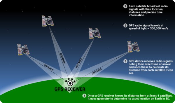
Thanks to on-the-shelf GPS modules/receivers from vendors like: Neoway and u-blox it’s easy to embed a GPS receiver into your project. What you need is a module sending its messages via UART to the MCU and a ready-made antenna attached to the module. There is a standard format for these modules messages called NEMEA. These messages contain information about the location that includes longitude, latitude, direction, speed … etc. These receivers need to see at least 4 satellites to compute a position.
There are many navigation systems like the Russian GLONASS, the European Union’s Galileo and the American GPS.
GPS is mainly designed to be an outdoor location detection system. Therefore, its performance decreases in enclosed places and across crowded areas with buildings.
WiFi
WiFi can be used in location detection (AKA Wi-Fi positioning system) when your phone or WiFi transceiver module like ESP32 or ESP8266 is near hotspots. You can consider WiFi like a coexisting system with GPS for indoor areas. Moreover, WiFi can be used to detect the location inside the enclosed/underground area; you can see the SubPos project on Hackaday to know how.
Read more: GPS vs. Beacons vs. Wi-Fi: Three Location Identifier Technologies
- What are the most common technologies used for user location identification?
GPS, WiFi, and Beacons (a custom BLE profile). - How does GPS provide location data to a project?
GPS modules send NMEA messages via UART to the MCU containing longitude, latitude, direction, speed, and other information. - Can GPS work indoors?
No; GPS performance decreases in enclosed places and across crowded areas with buildings because it needs to see at least four satellites. - When is WiFi useful for location detection?
WiFi is useful near hotspots and can be used for indoor positioning or in enclosed/underground areas when GPS is unreliable. - Which modules are mentioned for WiFi-based positioning?
ESP32 and ESP8266 WiFi transceiver modules are mentioned for location detection. - What role do Beacons play in location-based marketing?
Beacons use a custom BLE profile to provide proximity detection, useful for indoor geofencing and delivering location-based offers. - What is required for a GPS receiver to compute a position?
The receiver needs to see at least four satellites to compute a position. - Are there other satellite navigation systems besides GPS?
Yes; examples include the Russian GLONASS and the European Union's Galileo.
